skip to main |
skip to sidebar
 If the title makes no sense, then I guess you haven't experienced the Nepali karmic solution to dangerous driving conditions.

I just returned from my vacation to Nepal, Korea and Thailand last week and this is just one of the life lessons I learned while traveling in Nepal. I am still not sure if I have really figured out Nepal yet, but I had an absolutely amazing once-in-lifetime (but hopefully to be repeated) experience trekking near Annapurna. For this post I will just tell you a little bit about Nepal, since I could probably write a book each about the time I spent in Thailand and Korea. I am not even going to try a full travelogue since the three weeks spent in Nepal truly felt more like a 6-month odyssey. At least to me!

First of all, let me explain the title. On several occasions I had the pleasure of traveling on the narrow potholed and winding mountain roads which are the main vehicle highways in Nepal. One thing is certain, these road-trips were the most dangerous aspect of my entire solo hiking trip! Standard procedure whether in a 80's era taxi sedan, vintage Indian bus, or lumbering Tata freight truck, is to honk your horn repeatedly when passing another vehicle on the wrong side of the road (in the opposing traffic lane). Honking is of course used for all sorts of other reasons, but it is done with such singular and life-affirming purpose when passing a lumbering vehicle on an absolutely blind mountain corner that I became convinced that the horn is the #1 traffic safety device in Nepal. It appears, that whether or not the horn can be heard by the oncoming traffic makes no difference. Honking the horn relieves the driver of his responsibility to make sure that no one is coming. And since it seems there is rarely a pocket of road where safe passage around a slow vehicle can be visually verified the logic is to honk the horn and have trust in your karmic fate.

My taxi driver who drove me 5 hours to the beginning of the trek was kind enough to point out three blind-corner fatal car wrecks within the first 30 kms or so of our drive. He assured me that he felt getting to the destination alive was more important than speed, but I wonder a bit about how truthful he was being. He laughed when he showed me how his horn was only working intermittently!

Since I arrived in Kathmandu just before the beginning of Dashain (a big holiday) I had the choice of waiting several days to start my trek or hiring a taxi on the last day before travel was restricted. I hired a taxi to drive me to my starting point on the Annapurna trek. And then since half the Indian Ocean was dumping on the Himalayas when I arrived I jumped into a jeep to get to the end of "road". I began hiking from Bhule Bhule at about 5PM on October 6. I made it Ngadi and fell for the hard sell at the first guesthouse. Now I am starting to wish I kept a diary since there is no chance I can remember the guesthouse name. It seems most of the guesthouses have extremely predictable and completely un-original names like Ngadi Guesthouse or Ngadi Riverview Inn. On a sidenote a couple of easily remembered places and favorite stays were at the High Plains Inn in Tukche and Bob Marley Guesthouse in Muktinath.

Anyway, I really began to experience the trek when I started hiking on Oct. 7. I knew that the hike was supposed to take me from very modest elevations up to high elevations but I didn't realize until that day that I would actually be hiking through such lush relatively low elevation areas. I was just blown away by the beauty of walking through terraced farming areas. It seemed like I was passing through a small village every 20 or 30 minutes and marveling that these were no tourist villages. Most of the people in many of the small villages appeared to be living there much like their great-great grandparents probably did, living off the land.

The power lines arced overhead along many parts of the trail, but thanks to the lack of a road, the villages were quiet and relatively peaceful places. I was a bit dismayed to see how much garbage, plastic bottles and bags etc., littered the sides of the trail but it was easy to see that the further I got from the roads the less of the garbage I saw. Most of the time there were far more livestock droppings on the trail then garbage (rubbish).

The trail slowly wound up the ever-deepening canyons changing from lush tropical vegetation to more temperate pine forests. It was here in the pine forests between Tal and Chame where I started to feel at home. These forests were similar to many others which I have hiked. They were places were I could imagine deer and bears similar to those at home. The buildings also started to change to being sturdy wooden structures. In the lowlands the buildings seemed to just be mish-mash of whatever building materials were available, including plastic sheeting for walls and corrugated metal roofs. In Chame I stayed in a nice new wood lodge. It may not be nearly so enjoyable in a year or two, but at the time of my stay the all-wood floor, walls and ceiling was so fresh you could still smell the scent of the fresh-cut wood.

Although the forests were a lot like home in this particular area (Chame) the canyons were much deeper and slopes much steeper. Since the monsoon clouds were still stalking me I still could not see the tops of the hillsides, but it was obvious I was still at the bottom of huge mountains. The river at the base of the canyon was just a huge rushing torrent of whitewater. I crossed the river on countless swaying suspension bridges and wondered what life was like before the suspension bridges. Many of the villages would have been entirely cutoff from even the closest village, let alone the outside world, without a bridge. There was no other way to cross these rivers. In many places they are unfordable.

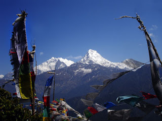
I think on day 4 the clouds cleared and the canyons started to open up into the large Manang valley. I took my friends' (Ana and Keith) advice and walked to Upper Pisang in order to stay in a guesthouse with good views. The accommodations here were a bit more rustic than in Lower Pisang (satellite dishes!) but the view of Annapurna III was incredible. Since I got here early I also took a stroll up the trail toward Pisang Peak base camp in order to acclimatize. The view from my high point was unbelievable! I sat and stared at the Annapurna massif from below flapping prayer flags until my fingers were numb. I also saw some sort of high alpine deer and a whole bunch of yaks grazing on the open slopes below Pisang. The soaring Lammergeiers seemed to be always floating overhead in these high beautiful places. The Lammergeier vultures appear to live such a charmed life, almost never flapping a wing, floating in some of the most beautiful places in the world. I aspire to be reincarnated as a Lammergeier.

After Upper Pisang I followed the upper trail out of Upper Pisang and was treated to fabulous view after fabulous view. This is one area where I regret not taking extra days. Here Tibetan influenced buddhist villages seem to sit on every prominent viewpoint. The buildings at these places are constructed almost entirely of stone. At the time I passed through many of the people were out harvesting grain. I watched them cutting the grain with the ever ubiquitous scythes, laying it out to dry and then tossing it to separate the chaff. If ever there was a shangri-la for me the area around Upper Pisang might just be it.

I stayed at Manang which is basically the last major settlement which is not solely devoted to tourists, prior to the Thorung La, highest pass of the trip. Although Manang is an ancient town and non-tourist oriented life abounds around it, most of the business in town is absolutely geared for the tourists. In fact they were showing movies the predictable movies Vertical Limit and Into Thin Air at a couple of places. There are several large lodges, some good bakeries and a fairly reliable power supply. If I remember correctly, Manang was at about 11,000 feet so many trekkers stay here for a couple of days to acclimatize. I tried to check out a monastery near Manang but it was closed when I visited. So I enjoyed a quiet sit with a couple of yaks on the monastery doorstep.

Personally I got tired of Manang quickly, probably due to the annoying presence of so many tourists. So after one night here I took off with the intention to get as far up toward the Thorung La as reasonable and to snag a good room at one of the few lodges before the pass. It wasn't my intention, but I ended up at the penultimate lodging before the pass at Thorung Phedi (4600m). There is only one higher place called High Camp. Fortunately, I got there just in time to snag one of the last spots in the dormitory.

Thorung Phedi is not a particularly enjoyable place and because I came down with traveller's diarrhea, for me it quickly become a somewhat dreadful place. I survived a terrible night of sickness with little sign of altitude problems, and so the next day I set off to cross the Thorung La, the highest point on the trek (5400m).

My trek to the pass was a bit of an anticlimactic struggle. I was so prepared to be utterly beaten, broken, sick and tired that I was not particularly impressed when I finally made it to the high point 2.5 hours after starting! By no means was it easy. I was sufficiently amazed at how difficult it is to breathe at nearly 18,000 feet, but the actual place didn't excite nearly as much as I had hoped. The place is primarily an iconic photo point for the thousands of trekkers who have paid and grunted their way to this high point. Most of the views of rock, ice and snow are little different than those I have seen elsewhere. There was ice/snow and a small teahouse at the top, but I did little more than take a photo before dropping off the other side of the pass. I was in a bit of a hurry to get away from the growing crowd and to get to warmer and more hospitable terrain.

That is enough for now! Tune in again for more unbelievable adventures from Adam's memory.

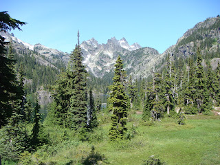 It has been a looong time since I ran a long race or even attended an ultra event. So this last weekend I became a little overwhelmed and re-energized hanging out with the great people at the Cascade Crest 100. In fact, I have once again caught the ultra-bug and am already starting to pine for an injury free and race filled next summer!

The plan was to do some hiking on Saturday near the CC100 course and then join Alison, James and Laura to man the No Name Ridge Aid Station during the middle of the night Sat-Sun. Amazingly the whole adventure went really smoothly, except for the fact that I technically still have two nagging injuries and am not in shape to be hiking/running 37 miles!

On Saturday morning I set off on a truly spectacular loop hike near the CC100 course. I hiked from the Cooper Lake trailhead up past the popular Pete Lake to the PCT. Then I hiked southbound on the PCT with a 2 hour stop at Spectacle lake to do some fishing. BTW, caught a beautiful fish which I think may have been a dolly varden (bull trout)??. The only thing I know is it didn't look like a cut and it didn't look like a rainbow so I am just guessing that it was a bull trout. After going over a pass I took a left on the Mineral Creek trail and followed this trail to the trailhead (Mineral Creek Aid Station). From this trailhead I ran and hiked the gravel roads back to the Cooper Lake trailhead. Some quick thoughts on a long hike:
-why spend half of your weekend vacation packing and re-packing a 1/2 ton beast of burden just so that you can spend some time at a horsefly ridden, horse trampled, and horse-shit strewn campsite? I just don't understand. And I am not sure if I ever will. To me at least, riding horses into the backcountry is so totally anachronistic.
-why does the military think it is ok to buzz people with supersonic aircraft and eliminate the peace and quiet of the last great quiet place: wilderness? At several times during my trip supersonic aircraft buzzed by overhead, completely covering over and drowning out the sound and the quiet of wilderness. And at one point I swear, a jet fighter, flew directly over me, about 500 to 1000 feet off the ground!
-How many hours does it take for a Cascade trail to become completely overgrown and to disappear? In many places the brush on the upper Mineral Creek trail towered over my head and complete blocked the trail. In fact, many times I could only tell there was a trail due to the broken brush from the previous hiker. Obviously, this is a fine trail to use to get away from the hordes, because you would have to be crazy to hike it just to see the nearly impenetrable wall of slide alder!

After leaving the Mineral Creek trail (thank god), I had to run most of the gravel roads back to my car so that I could make it to Village Pizza before it closed. I am absolutely convinced there may be nothing better than good pizza and beer immediately following a hike!
Finally around 10:30 PM I drove up to the No Name Ridge aid station where I met up with James. Unfortunately, James was injured in a race earlier in the day so I was saddled with the task of marking the race course for the 4.5 miles between No Name and Thorp Mountain. I was not thrilled to be doing an extra 9 miles of hiking from 11:30 PM to 3:00 AM. But by the time I was on my return to the station I was truly happy I had hiked this section of course. It was absolutely beautiful hiking along some of the open ridge areas under a clear, star-studded, and moonlit night sky. Night hiking can be a very rewarding experience.

The remainder of the night was spent at the Aid station providing relatively poor service to the runners. I was able to help out somewhat, but I think I could have done a much better job if I hadn't been quite so worn out!
It was truly amazing and inspiring to watch the runners running into the aid station and then soldiering on into the darkness on the other side. I can't wait until I get the chance to run CC100 next year!
 The best laid plans can bring happiness, peace and maybe even enlightenment. The worst laid plans can bring at the very least an uncomfortable, adventurous, and epic experience.
I usually put quite a bit of time into planning my weekend adventures. Especially around this time of year, when the mountains are nearly snow-free and the weather can be awesome. Usually a bit of careful planning pays off with beautiful views or solitude on the trails. But, unfortunately last weekend's plans were hastily made and poorly thought out. On saturday morning I woke up planning to do a difficult backpacking loop on the PCT (55 miles - 2 days) and immediately re-considered my plans due to poor weather conditions. Overnight a cloud had descended and enveloped my house and most of Washington state in a state of perpetual mist. Typical November weather in August!

I recall thinking, why not just head for the closest rain-shadow area and hope for clearing weather! So I read a few trail descriptions, pulled out my road atlas and found several trails which I thought I could combine to make one grand loop. I love to hike loops because you always get to see something new! Unfortunately, loops are not easy to plan, especially when you are in the mood to hike around 15-20 miles a day! Since I didn't have any decent trail maps for where I was going I checked out my road atlas. The road atlas is great because it shows a lot of trails and old gravel roads and it helps me visualize where I will be in relation to all the different access points. What I didn't realize is that many of the trails shown on the map may be old, abandoned or no longer exist! It also would have helped to really study the map scale so that I knew how far I had to hike.
My plan was fairly simple. Drive to the Lake Ingalls trailhead. Hike over Ingalls Pass to Lake Ingalls and then over Stuart Pass into the Jack Creek drainage. Hike down Jack Creek to the Meadow Creek trail. Take Meadow Creek trail until the junction with Snowall Creek / Cradle Lake trail. Follow this trail to Cradle Lake and camp at Cradle Lake. Sunday follow another trail west of Cradle lake which I thought was Snowall / Cradle back to Meadow Creek. Soon after going west on Meadow Creek I should have found a trail, possibly signed Solomon Creek which would take me to the Van Ness Pass area. From there I could get onto the Lake Ann / Esmeralda Basin trail which would take me back to the trailhead.
I left the always busy Lake Ingalls trailhead by 10 AM under a partially cloudy sky. Before long I was hiking past a mountain goat and climbing around the shoreline of Lake Ingalls, looking forward to the solitude I was certain to find on the other side of Stuart Pass. When I got to Stuart Pass I was surprised to see a forest fire on the eastern side of the Jack Creek valley. The fire didn't look too big from where I was and the wind appeared to be pushing it up the eastern side of the valley. I studied my map and figured out that the Jack Creek trail was on the opposite side of the river from the fire. Since the fire appeared to be moving away from my intended location and since I would be down in the wetter valley bottom by the time I was close to the fire I thought I could skirt past the fire. I have to admit I have also always wanted to see a forest fire from a relatively close, but safe position.

So I took off down the Jack Creek valley and in less than 1/2 an hour was hiking down valley under the constant thump thump thump of firefighting helicopters. As far as I could tell the helicopters were just observing and evaluating the fire. After reading a WTA report I later realized that they were probably setting up for a parachute hot-shot team. Fortunately, when I got closer to the fire it was obvious I would have no trouble skirting the fire since I couldn't even smell smoke. The wind was so powerful it was pushing all the smoke up the other side of the valley even though I came within an estimated 1/8 mile of the fire. It was cool watching several trees torching but I didn't stick around long since I had a sneaking suspicion that the flying cavalry wouldn't look to kindly on hikers in their war zone.

After another 1/2 hour or so of hiking through an eerily quiet forest I found the junction with the Meadow Creek trail and soon thereafter I forded Jack Creek. It was here that I used up the last of my water purification. I guess that with all the hiking I have been doing I forgot to check my supplies. Oh, well! I hoped the rest of the hike would be around relatively clean water sources.

Ever since Stuart Pass the trail had been becoming brushier and less well-maintained. When I soon turned onto the steep Snowall / Cradle trail I realized this trail had received very little use, let alone maintenance. At 6:30 PM I finally topped out at the Cradle Lake basin just as the clouds rolled in and it started to rain. I was happy to have the lake all to myself but was not really thrilled with the cold rain and wind which stuck around for most of the night. Suffice to say I didn't get to stare at the moon and contemplate life at the edge of an alpine lake. But at least my tarptent didn't blow over and I didn't get drenched in the rain!

The weather was still cold overcast and windy on Sunday morning but I figured I might as well see if anyone was hiding in the lake. So I setup my clunky beat-up fly rod and made a few poor casts. I think I got one strike before packing up to leave, but that could have just been a wind-driven whitecap sinking my fly! A quick climb to a small pass allowed my fingers to thaw-out.
From here I left the main Snowall / Cradle trail and followed an obvious path with lots of elk footprints to another ridgeline overlooking the Meadow Creek valley, just as my map indicated I should. And then the trail completely disappeared! I searched high and low and could not find a trail. So I started out going cross-country down the 2,000 foot high hillside. About halfway down I found the other hikers on the hillside: two elk and two deer grazing side by side. Scrambling down wet heather and through chest high slide alder reminded me why trailwork is so important.

Finally at the bottom of the valley I found the Meadow Creek trail again, except at this point in the valley the trail was little more than a game trail through swampy head-height slide alder. There were no blazes and in some areas the only sign of the trail was a single set of footprints with a corresponding flattening of the bushes. At this point I knew that I had virtually no chance of finding the Solomon Creek trail but I pressed on, committed to doing a loop, rather than returning via Saturday's route.

Eventually I dropped down into the French Creek valley and came to a junction with the French Creek trail. The remains of a collapsed wood cabin/shelter were located at the junction. I immediately took a left and headed up the hillside toward Sprite Lake and Paddy-Go-Easy Pass. After a bit of steep hiking I found myself above Sprite Lake at a pass where an old mine was located. Once again I could not find a trail going down the other side. I went down a bit and found large rock fields and potential steep cross-country travel. Due to my experiences that morning I decided to choose the trail more heavily traveled. I backtracked and went north along the ridge until I found Paddy-Go-Easy Pass and then immediately dropped down into the Cle Elum River drainage (toward Tucquala Lake). Because of my reluctance to travel cross-country I would need to descend 3 miles, then hike the Forest Service road about a mile to the Scatter Creek trailhead, and then hike something like 3 to 4 miles up Scatter Creek to attain another pass. Since it was already 2:30 PM I nearly started running!

By 4:15 PM I was briskly hiking up the south Scatter Creek trail hoping that I could find the trail at the pass or figure out a route to get to Lake Ann. I was familiar with the trail from Lake Ann to the trailhead so I was certain that once there I could put my legs on autopilot. As soon as I started to enter the alpine meadows the trail began to disappear below heavy vegetation and windfall. By paying careful attention to rare blazes, cairns and trampled vegetation I was able to work my way through the meadows and even across a huge avalanche debris field. Finally I scrambled up to a pass at 6:30 PM and looked down the other side into the Meadow Creek and Jack Creek valleys. Again, there was no obvious trail. Somehow I still needed to get around a couple of large mountains, one of which was Ingalls Peak.

In retrospect, this is the exact point where clear critical thinking is most important in an adventure of this sort. My body was tired, my mind a bit frazzled and my map was not detailed enough to lead me confidently in the correct direction. So I guessed which direction to go around a peak and hoped that I would be able to find climbable ground. My guess worked out but it turned out I misjudged my location by at least a couple of miles which further added to my confusion later that evening. Around 7:30 PM I found myself on top of another pass between two rocky peaks looking down into an unknown valley with no apparent trails. At least I could see a dirt road in the bottom of the valley, several miles from where I stood, but as the wind whipped over the ridge and the sun fell behind the western peaks I knew that I had a long night ahead.
I dropped into a beautiful little cirque and started heading in the direction which I guessed might put me near the Lake Ann trail. I was tempted to settle down for the night in the trees below the cirque, but I knew that I didn't have a lot of food, my tent and part of my sleeping bag were already soaked and if I didn't return soon I might be reported missing. Eventually I found a thin trail with blazes. I later discovered I had found the County Line trail, an old and very long trail which crosses many passes in the area. At 9PM just as it was getting dark, I finally found Van Epps Pass and was able to delineate exactly where I was on the map. From here I had a relatively uneventful 7 mile hike back to the trailhead in the dark. I got home at 3 AM and made my best and last plan for the weekend: to call in late for work on Monday morning.

Trail Conditions:
Ingalls Lake - clear, good condition
Jack Creek - some minor windfall, lost trail in swampy meadows
Snowall/Cradle - brushy areas
Meadow Creek - extremely brushy in spots, some windfall, lost trail in swamp meadows
French Creek - windfall, relatively good tread
Paddy-Go-Easy Pass - clear, relatively good condition
South Scatter Creek - extremely brushy in meadows, no tread in many areas, significant avalanche and windfall debris
County Line - very thin trail with no tread in meadows, windfall, disapears in alpine areas
Lake Ann / Esmeralda Basin - clear, good condition, water on some portions of trail
 This last weekend I went on my first backpacking trip of the summer season and boy was it a scorcher! Summer has finally arrived with a vengeance with 80's in the mountains and 90's in the lowlands.

It was time again for my annual perambulation through the Enchantment Lakes area near Leavenworth,WA. This year I got to share this place, one of my favorites, with three Enchantments rookies, Jim, Jessica and Alison. I know I had a great time on the hike and I think it was primarily due to the company. All three of these hikers had a pretty great attitude and seemed to really enjoy the Enchantments.

We started out on Friday at the Stuart Lake trailhead and headed straight up through a cloud of mosquitos to Colchuck Lake. Unfortunately, Jessica was not feeling well and became quite dehydrated during the day so we made a group decision to postpone the hike over Asgard pass until Saturday. We stopped at emerald Colchuck Lake hoping that Jessica would feel better on Saturday and that we would be able to escape from the mosquitos in the colder Enchantments. While everyone else settled into a camp in the boulders below Colchuck Peak I decided to burn some more energy and try for the summit of Colchuck Peak.

I remembered the last time I had climbed Colchuck I had been a relative neophyte to steep snow/ice walking and had been very grateful to have the comfort of crampons for the climb up the glacier. So this time I was a bit skeptical about how easy and safe it would be to hike it without crampons. After starting out at 4:45 PM I was surprised to find myself on the very top at 6:15 PM. The snowfield/glacier had been a relatively easy walk due to the fact that the top 3 or 4 inches was a bit slushy and some previous groups had left nice steps. The view from the top was spectacular especially since I could see all the WA state volcanoes except for Mt. St. Helens! The summit smelled a bit like a barnyard but I guess that is the price you pay for having the ubiquitous mountain goats in the mountains, where they belong.

On Friday evening Jim, Alison and I got to spend some quality hiker bonding time sipping a hiker margarita, staring at the brilliant stars and bs-ing about politics, theology and science, among other things. BTW, before this hike I did not know any of my hiking partners, although I had met Jim briefly on a Mountaineers hike a few weeks before. As far as I can tell Jim is a very entertaining professional conversationalist who should probably be on Jeopardy, Alison is a relatively hip young scientist who just happens to be a bit gullible and Jessica is someone who is committed to challenging herself.

On Saturday we struggled up the mighty Asgard Pass and entered the heavenly Enchantment Lakes Basin. Thankfully Alison and Jim were able to help out with carrying gear and hiking with Jessica so that we could all make it to the high point of the hike. Then we moseyed through the upper Enchantments before Jim, Alison and I dropped packs and headed for the summit of Little Annapurna. On top we were treated to the a spectacular view of a large portion of the Washington Cascades and the vertigo which comes from looking over the steep side of the peak. On the way up the mountain Alison got a quick lesson in ice axe self arrest and by the time we came down, I think she had nearly mastered the most important part of any climbing technique: confidence. We had no significant falls and I have a feeling that this was due more to the soft and quickly melting snow then our climbing technique. After the climbing we scrambled down to my favorite camp spot at Lake Viviane to settle in for another perfectly clear night of backcountry stargazing and sleeping.

After sleeping in on Sunday morning, we took our time wandering down the Snow Creek valley to the Snow Creek trailhead. Fortunately, we all survived without suffering from heat stroke.

During the weekend I did a few minutes of fishing at Snow Lakes and very little at Lake Viviane and Colchuck. I ended up getting skunked, partially due to the fact that there was still snow on Lake Viviane! But mostly due to my impatience, broken gear and poor fishing skills. Nonetheless, I enjoyed my time fishing on these beautiful crystal clear lakes.

I can't wait to go back!!

 Today was Damon's birthday. I find it particularly weird that I often have trouble remembering some of my brother's and sister's birthdays, but June 3rd, my dead brother's birthday is easily remembered. Maybe it has to do with that one June 3rd when we were kids and my brother Micah was in the hospital with pneumonia. I remember how I didn't really know what to feel on that day since I was worried about my sick brother. But at the same time I was wondering, how does Damon, my other brother, feel? His birthday is today and everyone is too busy and too worried to really celebrate his birthday. I think we actually did do the whole presents and cake thing but I don't remember much about that. What stands out is that just as Micah was starting to recover and our Dad had just returned to his job which was over 150 miles away, my dad's dad died.
I could be mis-remembering the exact timeline or minor details. But I definitely remember the strange sense of dread I felt at that time. When the whole world seems to start falling apart it can be extremely unnerving, especially for a kid. Prior to this time I believed my parents and other grown-ups could make everything ok. Doctors could always solve a problem. My dad could fix the problem like he fixed the car. God wouldn't allow terrible things to happen to you if you were good. The very idea that we are all mortal, that we live in a wild and crazy world where everything is not always fair, that good guys don't always win and that a birthday present may not make you feel better, was, and sometimes still is, shocking.
Of course I am old enough to know better. I have hit the potholes in life and been totally washed clean of my childhood naivete. It really is not so much that bad things can happen, but that they sometimes happen to good people doing all the right things at all the right times. The idea that at the core of all things chance might be the determining factor is overwhelmingly depressing. It is much easier to live day to day if you allow for the delusion or illusion that someone somewhere is in charge and they are looking out for you and your world. Whether it be karma, fate, God, or a bit of optimistic thinking, sometimes you've just gotta believe it will all work out. Today, I believe.
 The other day, while biking to work during a cold and miserable rainstorm, I was jolted out of my funk by a simple but inspiring bumper sticker. It read "Got Hope?" Of course I know that the purpose of this message has to do with a certain political campaign, but to me, at least on that day, 'got hope' resonated as much more than a slick marketing campaign. I realized just how important hope is to my overall outlook on life, and it has little if anything to do with the current presidential campaign.
If you can't hope for a better, happier, more fulfilling future life, than your present life can sometimes seem boring, dull and pointless. That doesn't mean your, or in this case, my present life is all bad. Sometimes it just seems a bit uninspiring.
In the past, a lot of my hopes and dreams hinged on running goals and far-out ultra-running dreams. Since my right knee seems to be on the quick path to retirement I have had a hard time hoping for better running days. So I am trying to concentrate on other hopes and goals.
I am starting to plan a vacation to Nepal so that I can hike around Annapurna in October. In addition, I am starting to wonder if my knee will let me take a few long epic hikes this summer.
Hope can do amazing things to your outlook. Here's to hoping that you've got Hope! It is far better than milk and less likely to give you gas.
 Last year I became a real blog post slacker. This year I am trying to do better but actually doing even worse! I always want to post about the fun stuff I do right after it happens, but then I get caught up in everything else and forget about it until I sit down at the computer with some free time. By then I usually have a hard time remembering what I wanted to post about. Guess I need to start posting from a fancy mobile device with speech recognition. Then I could do the post while driving home from a weekend adventure!
Anyway . . . The subject of this post is my second trip to Cal's cabin this winter. I am truly blessed to have been able to visit the cabin twice this winter. And both times I had a blast! The first time the snow was fresh and gnarly. The second time the weather was awesome and the food was exceptional. Of course the company on both trips was superb.

On the weekend of Feb. 16-17 I visited the cabin for part of the holiday weekend and hung out with Calvin, Kristen, Belinda, Bruce and Kat. They all were smart enough to plan for a three day trip. Whereas I had to be back to work on monday, so missed a 3rd glorious day:( Belinda, Bruce and Kat were friends of Cal and Kristen's from Mt. Vernon.
I skied in by myself on Saturday, got the cabin setup, and skied up the hill north/east of Little Boulder Creek. Although the snow had a pretty nasty wind/freeze crust the sky was virtually cloud free and the daytime temperature must have been near 50 degrees. I had a great time skinning up the hill, following animal tracks, and checking out the views of the valley. At the top I had a great view toward the Mt. Cashmere and Mt. Stuart area but couldn't pick out any known peaks in that direction. Guess I wasn't high enough! I could see Mt. Daniel further up the valley and another peak, Granite or Trico (?), with sled high-marks on a damn near 40 degree slope. I find it slightly comforting to know that natural selection is still at work in the human population! I skied back down to the cabin, trying to stay off of the most wind-laden avalanche prone slopes.

Everyone else finally made it to the cabin, just in time for a great dinner prepared by Calvin and Kristen. Afterwards the wine and conversation flowed freely. Unfortunately for me I had brought enough alcohol for two nights instead of one. So I ended up drinking too much and belligerently arguing social science, conservation and land use with Kat, Belinda and Kristen (three conservation professionals). At least Kristen and Calvin are used to my penchant to play devils advocate. But I am certain I put on a sorry and somewhat scary show for poor Kat, Belinda, and Bruce. I hope they had as much fun as I did!

Sunday dawned just as clear and glorious as Saturday. But my hangover tempered my enjoyment of the beautiful morning. Thank goodness everyone else seemed to be in no hurry to hit the slopes. We spent the entire morning and part of the afternoon just eating, napping, talking, reading and playing card games. Around 2 pm when we were getting ready to do some xc shred'n the cabin just started shaking violently for about 5-10 seconds. I had just enough time to wonder: is this an earthquake and what should I do, before the shaking ceased. We looked outside to find that the entire roof snow load had split and slid off the roof leaving huge snow slabs on two sides of the cabin. This was a new one for me, and I think everyone else involved. It am sure glad I wasn't standing outside below the roof overhang, taking a leak when the roof decided to let loose!

All of us except for Kristen went on a little ski trip down in the valley. We toured around the Cle Elum River, checked out some frozen ice by the river, followed a bearprint trail, met some people at a cool yurt and enjoyed the sunshine. By the time we returned it was time for me to leave. So I packed up and had a relatively uneventful but very serene nighttime ski out to the car.

Thanks to my friends Cal and Kristen for organizing such a fun weekend. I had a fabulous time meeting Belinda, Bruce and Kat and enjoying the cabin, once again.