skip to main |
skip to sidebar
 It has been a looong time since I ran a long race or even attended an ultra event. So this last weekend I became a little overwhelmed and re-energized hanging out with the great people at the Cascade Crest 100. In fact, I have once again caught the ultra-bug and am already starting to pine for an injury free and race filled next summer!

The plan was to do some hiking on Saturday near the CC100 course and then join Alison, James and Laura to man the No Name Ridge Aid Station during the middle of the night Sat-Sun. Amazingly the whole adventure went really smoothly, except for the fact that I technically still have two nagging injuries and am not in shape to be hiking/running 37 miles!

On Saturday morning I set off on a truly spectacular loop hike near the CC100 course. I hiked from the Cooper Lake trailhead up past the popular Pete Lake to the PCT. Then I hiked southbound on the PCT with a 2 hour stop at Spectacle lake to do some fishing. BTW, caught a beautiful fish which I think may have been a dolly varden (bull trout)??. The only thing I know is it didn't look like a cut and it didn't look like a rainbow so I am just guessing that it was a bull trout. After going over a pass I took a left on the Mineral Creek trail and followed this trail to the trailhead (Mineral Creek Aid Station). From this trailhead I ran and hiked the gravel roads back to the Cooper Lake trailhead. Some quick thoughts on a long hike:
-why spend half of your weekend vacation packing and re-packing a 1/2 ton beast of burden just so that you can spend some time at a horsefly ridden, horse trampled, and horse-shit strewn campsite? I just don't understand. And I am not sure if I ever will. To me at least, riding horses into the backcountry is so totally anachronistic.
-why does the military think it is ok to buzz people with supersonic aircraft and eliminate the peace and quiet of the last great quiet place: wilderness? At several times during my trip supersonic aircraft buzzed by overhead, completely covering over and drowning out the sound and the quiet of wilderness. And at one point I swear, a jet fighter, flew directly over me, about 500 to 1000 feet off the ground!
-How many hours does it take for a Cascade trail to become completely overgrown and to disappear? In many places the brush on the upper Mineral Creek trail towered over my head and complete blocked the trail. In fact, many times I could only tell there was a trail due to the broken brush from the previous hiker. Obviously, this is a fine trail to use to get away from the hordes, because you would have to be crazy to hike it just to see the nearly impenetrable wall of slide alder!

After leaving the Mineral Creek trail (thank god), I had to run most of the gravel roads back to my car so that I could make it to Village Pizza before it closed. I am absolutely convinced there may be nothing better than good pizza and beer immediately following a hike!
Finally around 10:30 PM I drove up to the No Name Ridge aid station where I met up with James. Unfortunately, James was injured in a race earlier in the day so I was saddled with the task of marking the race course for the 4.5 miles between No Name and Thorp Mountain. I was not thrilled to be doing an extra 9 miles of hiking from 11:30 PM to 3:00 AM. But by the time I was on my return to the station I was truly happy I had hiked this section of course. It was absolutely beautiful hiking along some of the open ridge areas under a clear, star-studded, and moonlit night sky. Night hiking can be a very rewarding experience.

The remainder of the night was spent at the Aid station providing relatively poor service to the runners. I was able to help out somewhat, but I think I could have done a much better job if I hadn't been quite so worn out!
It was truly amazing and inspiring to watch the runners running into the aid station and then soldiering on into the darkness on the other side. I can't wait until I get the chance to run CC100 next year!
 The best laid plans can bring happiness, peace and maybe even enlightenment. The worst laid plans can bring at the very least an uncomfortable, adventurous, and epic experience.
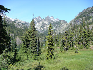
I usually put quite a bit of time into planning my weekend adventures. Especially around this time of year, when the mountains are nearly snow-free and the weather can be awesome. Usually a bit of careful planning pays off with beautiful views or solitude on the trails. But, unfortunately last weekend's plans were hastily made and poorly thought out. On saturday morning I woke up planning to do a difficult backpacking loop on the PCT (55 miles - 2 days) and immediately re-considered my plans due to poor weather conditions. Overnight a cloud had descended and enveloped my house and most of Washington state in a state of perpetual mist. Typical November weather in August!

I recall thinking, why not just head for the closest rain-shadow area and hope for clearing weather! So I read a few trail descriptions, pulled out my road atlas and found several trails which I thought I could combine to make one grand loop. I love to hike loops because you always get to see something new! Unfortunately, loops are not easy to plan, especially when you are in the mood to hike around 15-20 miles a day! Since I didn't have any decent trail maps for where I was going I checked out my road atlas. The road atlas is great because it shows a lot of trails and old gravel roads and it helps me visualize where I will be in relation to all the different access points. What I didn't realize is that many of the trails shown on the map may be old, abandoned or no longer exist! It also would have helped to really study the map scale so that I knew how far I had to hike.
My plan was fairly simple. Drive to the Lake Ingalls trailhead. Hike over Ingalls Pass to Lake Ingalls and then over Stuart Pass into the Jack Creek drainage. Hike down Jack Creek to the Meadow Creek trail. Take Meadow Creek trail until the junction with Snowall Creek / Cradle Lake trail. Follow this trail to Cradle Lake and camp at Cradle Lake. Sunday follow another trail west of Cradle lake which I thought was Snowall / Cradle back to Meadow Creek. Soon after going west on Meadow Creek I should have found a trail, possibly signed Solomon Creek which would take me to the Van Ness Pass area. From there I could get onto the Lake Ann / Esmeralda Basin trail which would take me back to the trailhead.
I left the always busy Lake Ingalls trailhead by 10 AM under a partially cloudy sky. Before long I was hiking past a mountain goat and climbing around the shoreline of Lake Ingalls, looking forward to the solitude I was certain to find on the other side of Stuart Pass. When I got to Stuart Pass I was surprised to see a forest fire on the eastern side of the Jack Creek valley. The fire didn't look too big from where I was and the wind appeared to be pushing it up the eastern side of the valley. I studied my map and figured out that the Jack Creek trail was on the opposite side of the river from the fire. Since the fire appeared to be moving away from my intended location and since I would be down in the wetter valley bottom by the time I was close to the fire I thought I could skirt past the fire. I have to admit I have also always wanted to see a forest fire from a relatively close, but safe position.

So I took off down the Jack Creek valley and in less than 1/2 an hour was hiking down valley under the constant thump thump thump of firefighting helicopters. As far as I could tell the helicopters were just observing and evaluating the fire. After reading a WTA report I later realized that they were probably setting up for a parachute hot-shot team. Fortunately, when I got closer to the fire it was obvious I would have no trouble skirting the fire since I couldn't even smell smoke. The wind was so powerful it was pushing all the smoke up the other side of the valley even though I came within an estimated 1/8 mile of the fire. It was cool watching several trees torching but I didn't stick around long since I had a sneaking suspicion that the flying cavalry wouldn't look to kindly on hikers in their war zone.

After another 1/2 hour or so of hiking through an eerily quiet forest I found the junction with the Meadow Creek trail and soon thereafter I forded Jack Creek. It was here that I used up the last of my water purification. I guess that with all the hiking I have been doing I forgot to check my supplies. Oh, well! I hoped the rest of the hike would be around relatively clean water sources.

Ever since Stuart Pass the trail had been becoming brushier and less well-maintained. When I soon turned onto the steep Snowall / Cradle trail I realized this trail had received very little use, let alone maintenance. At 6:30 PM I finally topped out at the Cradle Lake basin just as the clouds rolled in and it started to rain. I was happy to have the lake all to myself but was not really thrilled with the cold rain and wind which stuck around for most of the night. Suffice to say I didn't get to stare at the moon and contemplate life at the edge of an alpine lake. But at least my tarptent didn't blow over and I didn't get drenched in the rain!

The weather was still cold overcast and windy on Sunday morning but I figured I might as well see if anyone was hiding in the lake. So I setup my clunky beat-up fly rod and made a few poor casts. I think I got one strike before packing up to leave, but that could have just been a wind-driven whitecap sinking my fly! A quick climb to a small pass allowed my fingers to thaw-out.
From here I left the main Snowall / Cradle trail and followed an obvious path with lots of elk footprints to another ridgeline overlooking the Meadow Creek valley, just as my map indicated I should. And then the trail completely disappeared! I searched high and low and could not find a trail. So I started out going cross-country down the 2,000 foot high hillside. About halfway down I found the other hikers on the hillside: two elk and two deer grazing side by side. Scrambling down wet heather and through chest high slide alder reminded me why trailwork is so important.

Finally at the bottom of the valley I found the Meadow Creek trail again, except at this point in the valley the trail was little more than a game trail through swampy head-height slide alder. There were no blazes and in some areas the only sign of the trail was a single set of footprints with a corresponding flattening of the bushes. At this point I knew that I had virtually no chance of finding the Solomon Creek trail but I pressed on, committed to doing a loop, rather than returning via Saturday's route.

Eventually I dropped down into the French Creek valley and came to a junction with the French Creek trail. The remains of a collapsed wood cabin/shelter were located at the junction. I immediately took a left and headed up the hillside toward Sprite Lake and Paddy-Go-Easy Pass. After a bit of steep hiking I found myself above Sprite Lake at a pass where an old mine was located. Once again I could not find a trail going down the other side. I went down a bit and found large rock fields and potential steep cross-country travel. Due to my experiences that morning I decided to choose the trail more heavily traveled. I backtracked and went north along the ridge until I found Paddy-Go-Easy Pass and then immediately dropped down into the Cle Elum River drainage (toward Tucquala Lake). Because of my reluctance to travel cross-country I would need to descend 3 miles, then hike the Forest Service road about a mile to the Scatter Creek trailhead, and then hike something like 3 to 4 miles up Scatter Creek to attain another pass. Since it was already 2:30 PM I nearly started running!

By 4:15 PM I was briskly hiking up the south Scatter Creek trail hoping that I could find the trail at the pass or figure out a route to get to Lake Ann. I was familiar with the trail from Lake Ann to the trailhead so I was certain that once there I could put my legs on autopilot. As soon as I started to enter the alpine meadows the trail began to disappear below heavy vegetation and windfall. By paying careful attention to rare blazes, cairns and trampled vegetation I was able to work my way through the meadows and even across a huge avalanche debris field. Finally I scrambled up to a pass at 6:30 PM and looked down the other side into the Meadow Creek and Jack Creek valleys. Again, there was no obvious trail. Somehow I still needed to get around a couple of large mountains, one of which was Ingalls Peak.

In retrospect, this is the exact point where clear critical thinking is most important in an adventure of this sort. My body was tired, my mind a bit frazzled and my map was not detailed enough to lead me confidently in the correct direction. So I guessed which direction to go around a peak and hoped that I would be able to find climbable ground. My guess worked out but it turned out I misjudged my location by at least a couple of miles which further added to my confusion later that evening. Around 7:30 PM I found myself on top of another pass between two rocky peaks looking down into an unknown valley with no apparent trails. At least I could see a dirt road in the bottom of the valley, several miles from where I stood, but as the wind whipped over the ridge and the sun fell behind the western peaks I knew that I had a long night ahead.
I dropped into a beautiful little cirque and started heading in the direction which I guessed might put me near the Lake Ann trail. I was tempted to settle down for the night in the trees below the cirque, but I knew that I didn't have a lot of food, my tent and part of my sleeping bag were already soaked and if I didn't return soon I might be reported missing. Eventually I found a thin trail with blazes. I later discovered I had found the County Line trail, an old and very long trail which crosses many passes in the area. At 9PM just as it was getting dark, I finally found Van Epps Pass and was able to delineate exactly where I was on the map. From here I had a relatively uneventful 7 mile hike back to the trailhead in the dark. I got home at 3 AM and made my best and last plan for the weekend: to call in late for work on Monday morning.

Trail Conditions:
Ingalls Lake - clear, good condition
Jack Creek - some minor windfall, lost trail in swampy meadows
Snowall/Cradle - brushy areas
Meadow Creek - extremely brushy in spots, some windfall, lost trail in swamp meadows
French Creek - windfall, relatively good tread
Paddy-Go-Easy Pass - clear, relatively good condition
South Scatter Creek - extremely brushy in meadows, no tread in many areas, significant avalanche and windfall debris
County Line - very thin trail with no tread in meadows, windfall, disapears in alpine areas
Lake Ann / Esmeralda Basin - clear, good condition, water on some portions of trail